WHAT IS SEDIMENT?

A Simple Answer
Sediment is natural material—such as sand, silt, clay, decaying leaves, aquatic plants, and other organic matter—that is carried by water and eventually settles on the bottom of a lake, river, or channel.
Why It Matters to the Five Lakes
Sediment is continually transported through the Five Lakes watershed. Over many decades, this material has accumulated in portions of the channels connecting the lakes, reducing water depth and changing aquatic habitat.
The Science
Sediment is a natural part of every aquatic ecosystem. Problems develop when sediment accumulates faster than natural processes can transport or redistribute it.
Common Misunderstanding
Myth: Sediment is pollution.
Fact: Sediment is a natural material. The concern is excessive accumulation, not the existence of sediment itself.
Five Lakes Example
The Hackenberg–Messick channel has accumulated decades of sediment delivered from upstream portions of the watershed.
Did You Know?
A single grain of clay can remain suspended in water for days or even weeks before settling.
Resources and Further Reading
Primary Sources
- EPA
- Indiana DNR
- IDEM
- USGS
- University Extension publications
Five Lakes References
- Local studies
- Grant applications
- Engineering reports
- Historical documents
- Lake association publications
WHAT IS SEDIMENTATION?

A Simple Answer
Sedimentation is the natural process of sediment settling from the water and accumulating on the lake or stream bottom.
Why It Matters
Every rainfall carries tiny particles downstream. As water slows within lakes and channels, those particles settle and gradually build up over many years.
The Science
The speed of moving water determines how much sediment it can carry. When flow slows, gravity causes particles to settle.
Common Misunderstanding
Sedimentation cannot be stopped completely. It is a natural process that can only be slowed through good watershed management.
Five Lakes Example
Sediment entering Hackenberg Lake eventually settles where water velocity decreases before reaching Messick Lake.
Did You Know?
Many Indiana lakes have been slowly filling with sediment since the glaciers retreated thousands of years ago.
Resources and Further Reading
Primary Sources
- EPA
- Indiana DNR
- IDEM
- USGS
- University Extension publications
Five Lakes References
- Local studies
- Grant applications
- Engineering reports
- Historical documents
- Lake association publications
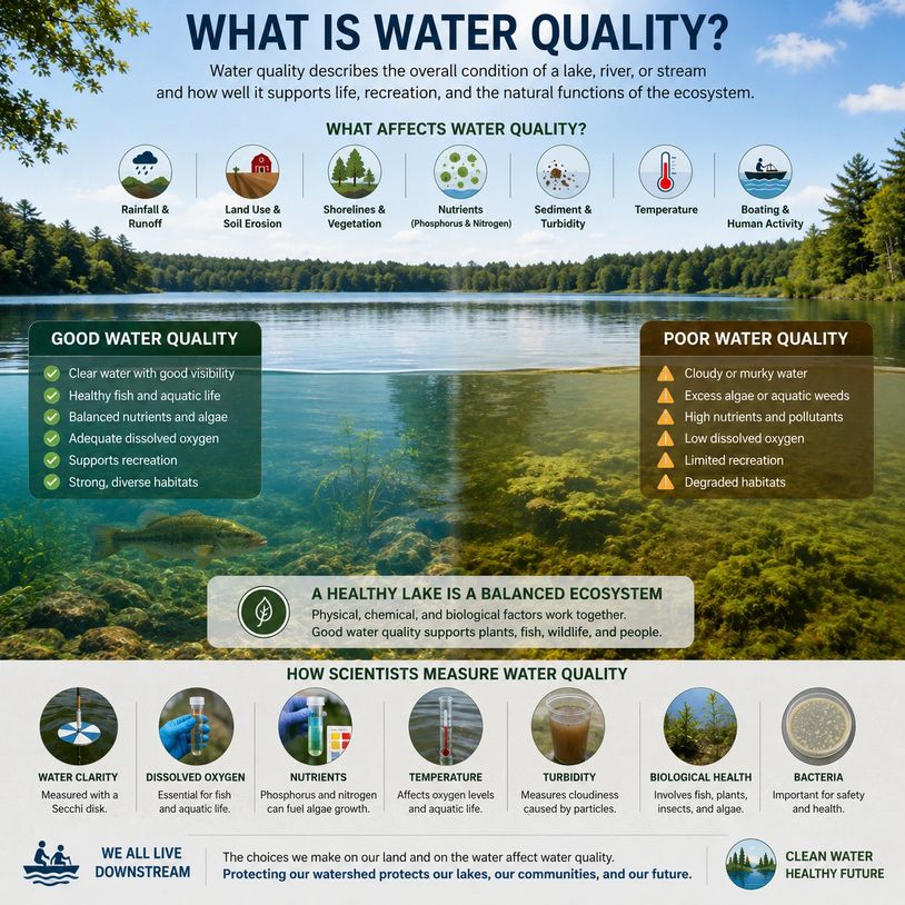
What Is Water Quality?
A Simple Answer
Water quality describes the overall condition of a lake, river, or stream and how well it supports the many ways people and nature use it.
Good water quality means the water is healthy enough to support fish and wildlife, provide recreational opportunities, sustain aquatic plants, and perform the natural functions of a healthy ecosystem.
Water quality is influenced by many factors, including:
- Water clarity
- Dissolved oxygen
- Nutrient levels
- Sediment
- Temperature
- Aquatic plants
- Algae
- Bacteria
- Chemical pollutants
In simple terms, water quality answers the question: "How healthy is the water?"
Why It Matters
Healthy water is essential for both people and wildlife.
Good water quality helps:
- Support healthy fish populations.
- Provide habitat for birds, turtles, frogs, and aquatic insects.
- Maintain balanced aquatic plant communities.
- Improve swimming, boating, kayaking, and fishing.
- Protect property values.
- Preserve the natural beauty of the lakes.
- Reduce the need for costly restoration projects.
For the Five Lakes watershed, protecting water quality means protecting the health of the entire connected lake system. Because water flows from one lake to the next, conditions upstream influence the lakes downstream.
Maintaining good water quality is one of the primary goals of lake stewardship.
The Science
Scientists evaluate water quality by measuring a combination of physical, chemical, and biological characteristics rather than relying on a single measurement.
Physical Characteristics
These describe the water's appearance and movement.
Examples include:
- Water clarity
- Transparency
- Turbidity
- Temperature
- Sediment
- Color
Chemical Characteristics
These describe substances dissolved in the water.
Examples include:
- Dissolved oxygen
- pH
- Phosphorus
- Nitrogen
- Minerals
- Other naturally occurring and human-made chemicals
Biological Characteristics
These describe the living organisms within the lake.
Examples include:
- Fish populations
- Aquatic plants
- Algae
- Aquatic insects
- Plankton
- Bacteria
Scientists evaluate all of these characteristics together because no single measurement tells the complete story of a lake's health.
For example, a lake may have excellent water clarity but low dissolved oxygen, or it may appear cloudy after a storm while still supporting a healthy ecosystem.
Common Misunderstanding
Myth: Clear water always means good water quality.
Fact: Water quality is much more than how the water looks.
A lake may appear crystal clear while still containing excessive nutrients, harmful bacteria, invasive species, or low dissolved oxygen. Likewise, water may become temporarily cloudy after a storm because of suspended sediment while remaining a healthy aquatic ecosystem.
Another common misconception is that water quality depends on only one issue, such as algae or sediment. In reality, water quality reflects the interaction of physical, chemical, and biological processes throughout the entire watershed.
Five Lakes Example
Water quality in the Five Lakes watershed is influenced by everything that happens within the approximately 35,000-acre watershed. Rainfall, tributaries, shoreline conditions, wetlands, agricultural runoff, aquatic vegetation, sediment movement, and seasonal weather all play important roles.
Because the lakes are connected, protecting water quality is a shared responsibility among all five lake communities.
Did You Know?
Scientists often describe a lake as an ecosystem rather than simply a body of water. Healthy water quality depends on the balance between water, land, plants, fish, insects, microorganisms, weather, and human activities throughout the watershed.
Resources and Further Reading
Primary Sources
- EPA
- Indiana DNR
- IDEM
- USGS
- University Extension publications
Five Lakes References
- Local studies
- Grant applications
- Engineering reports
- Historical documents
- Lake association publications
What Is Turbidity?
A Simple Answer
Turbidity is a measure of how cloudy or murky water is because of tiny particles suspended in it. The more suspended particles in the water, the higher the turbidity and the less clear the water appears.
These particles may include:
- Fine soil (silt and clay)
- Organic matter
- Algae
- Microscopic organisms
- Other suspended materials
Think of looking through a clean window versus a foggy window. The foggier the window, the harder it is to see through it. Turbidity measures that same loss of clarity in water.
Why It Matters
Turbidity is one of the easiest indicators of changes occurring in a lake or stream. While temporary increases are often a natural response to rainfall or wind, prolonged or excessive turbidity can indicate that too much sediment, algae, or other material is entering the water.
High turbidity can:
- Reduce water clarity and visibility.
- Block sunlight needed by beneficial aquatic plants.
- Make it more difficult for fish that hunt by sight to find food.
- Transport nutrients, such as phosphorus, that encourage algae growth.
- Reduce the recreational enjoyment and scenic beauty of a lake.
- Indicate increased erosion or excessive sediment entering the watershed.
For the Five Lakes watershed, monitoring turbidity helps us better understand how storms, runoff, dredging, and other activities affect water quality.
The Science
Turbidity is an optical property of water. Instead of measuring the amount of sediment directly, it measures how much suspended particles scatter and absorb light.
Water with very few suspended particles allows light to pass through easily and appears clear. As the number of suspended particles increases, light is scattered in many directions, making the water appear cloudy.
Scientists commonly measure turbidity in Nephelometric Turbidity Units (NTU) using an electronic instrument called a turbidity meter.
Although turbidity is often caused by suspended sediment, it can also be caused by:
- Algae blooms
- Organic matter
- Microscopic organisms
- Fine air bubbles
- Colored dissolved substances
Because of this, turbidity does not tell us exactly what is causing the cloudiness—it simply measures how cloudy the water is.
Common Misunderstanding
Myth: Turbidity and suspended sediment are the same thing.
Fact: They are closely related but are not the same.
Turbidity measures how cloudy the water appears.
Suspended sediment refers specifically to the soil and other particles floating in the water.
For example, an algae bloom can create very high turbidity even though very little soil is suspended in the water. Likewise, a storm may create high turbidity because large amounts of fine sediment have washed into the lake.
Resources and Further Reading
Primary Sources
- EPA
- Indiana DNR
- IDEM
- USGS
- University Extension publications
Five Lakes References
- Local studies
- Grant applications
- Engineering reports
- Historical documents
- Lake association publications
What Is Water Clarity?
A Simple Answer
Water clarity describes how clear the water is and how deeply sunlight can penetrate below the surface. Clear water allows you to see farther into the lake, while poor water clarity limits visibility because particles or organisms in the water block or scatter light.
Water clarity is influenced by many factors, including:
- Suspended sediment
- Algae
- Organic matter
- Water color
- Tiny microscopic organisms
Water clarity is one of the simplest ways to judge the overall appearance and condition of a lake.
Why It Matters
Water clarity affects nearly every part of a lake ecosystem.
Good water clarity allows sunlight to reach deeper into the water, supporting healthy aquatic plants that provide food, oxygen, and habitat for fish and other wildlife. It also improves swimming, boating, fishing, and the scenic beauty of the lake.
Poor water clarity can:
- Reduce the amount of sunlight reaching underwater plants.
- Affect fish that rely on sight to find food.
- Indicate increased sediment runoff or algae growth.
- Reduce the recreational enjoyment of the lake.
- Signal changes in water quality that deserve further investigation.
For the Five Lakes watershed, tracking water clarity helps residents and lake managers recognize changes over time and better understand how weather, runoff, algae, and sediment affect the health of the lakes.
The Science
Water clarity is determined by how much light can pass through the water before it is absorbed or scattered.
Particles suspended in the water—such as clay, silt, algae, or organic matter—scatter sunlight, reducing visibility beneath the surface. The more particles present, the less light can penetrate, and the poorer the water clarity.
Scientists often measure water clarity using a Secchi disk, a round black-and-white disk lowered into the water until it is no longer visible. The depth at which the disk disappears is called the Secchi depth, and it provides a simple, consistent way to monitor changes in water clarity over time.
Although water clarity and water quality are related, they are not the same. A lake can appear very clear while still containing high levels of dissolved nutrients or pollutants that cannot be seen with the naked eye.
Common Misunderstanding
Myth: Clear water always means healthy water.
Fact: Clear water does not always indicate good water quality.
A lake may appear crystal clear but still contain excessive nutrients, harmful bacteria, invasive species, or pollutants that are invisible. Likewise, a lake may appear cloudy for a short time after a storm because of suspended sediment, yet still be functioning as a healthy ecosystem.
Water clarity is an important indicator of lake conditions, but it should always be considered alongside other measures such as dissolved oxygen, nutrient levels, aquatic plant communities, and biological health.
Did You Know?
Many lake associations measure water clarity every year using a Secchi disk. Over time, these measurements help identify long-term trends and evaluate whether lake management efforts are improving or protecting water quality.
Resources and Further Reading
Primary Sources
- EPA
- Indiana DNR
- IDEM
- USGS
- University Extension publications
Five Lakes References
- Local studies
- Grant applications
- Engineering reports
- Historical documents
- Lake association publications
What Is Transparency?
A Simple Answer
Transparency is a measure of how far you can see into the water. It indicates how deeply light can penetrate before objects below the surface are no longer visible.
Transparency is commonly measured using a Secchi disk—a circular black-and-white disk that is slowly lowered into the water. The depth at which the disk disappears from view is called the Secchi depth or transparency reading. In simple terms, the deeper you can see into the water, the greater the transparency.
Why It Matters
Transparency provides a quick and reliable way to monitor changes in a lake over time.
Changes in transparency can indicate:
- Increased sediment entering the lake after heavy rainfall.
- Algae blooms developing during the summer.
- Seasonal changes in water conditions.
- Improvements or declines in overall lake health.
For the Five Lakes watershed, regular transparency measurements can help lake associations and residents recognize long-term trends and evaluate the effectiveness of lake management efforts.
Because the equipment is inexpensive and easy to use, transparency is one of the most common measurements collected by lake volunteers across the country.
The Science
Transparency is measured by lowering a Secchi disk into the water until it disappears from sight. The depth at which it disappears is recorded as the Secchi depth, usually in feet or meters.
Transparency depends on how much sunlight is scattered or absorbed by materials in the water. Lower transparency can result from:
- Suspended sediment
- Algae
- Organic matter
- Microscopic organisms
- Water color caused by dissolved natural compounds
Because transparency measures how deeply light penetrates the water, it is closely related to the growth of submerged aquatic plants. Plants require sunlight for photosynthesis, so clearer water generally allows plants to grow at greater depths.
Scientists often use transparency measurements as one of several indicators of lake health, along with dissolved oxygen, nutrient levels, chlorophyll (algae), and water chemistry.
Common Misunderstanding
Myth: Transparency and turbidity are the same thing.
Fact: They are related, but they measure different things.
- Transparency measures how deeply you can see into the water.
- Turbidity measures how much suspended material is causing the water to appear cloudy.
For example, a lake with an algae bloom may have poor transparency because sunlight cannot penetrate very deeply. Another lake may have poor transparency after a storm because suspended sediment is clouding the water. Although both situations reduce transparency, the causes are different.
Transparency is an easy field measurement, while turbidity is usually measured electronically with specialized instruments.
Did You Know?
The Secchi disk was invented in 1865 by Italian astronomer Father Pietro Angelo Secchi. More than 150 years later, it remains one of the simplest and most widely used scientific tools for monitoring lakes around the world.
Resources and Further Reading
Primary Sources
- EPA
- Indiana DNR
- IDEM
- USGS
- University Extension publications
Five Lakes References
- Local studies
- Grant applications
- Engineering reports
- Historical documents
- Lake association publications
What Is a Watershed?
A Simple Answer
A watershed is all the land area where rain and melting snow drain into the same lake, river, stream, or other body of water.
Imagine placing a bowl on a table and pouring water anywhere inside the rim. No matter where the water lands, it eventually flows to the bottom of the bowl. A watershed works much the same way. The surrounding hills, ridges, and higher ground form the "rim," directing water downhill through streams, ditches, wetlands, and tributaries until it reaches a common destination.
For the Five Lakes, the watershed includes thousands of acres of farmland, forests, wetlands, roads, homes, and streams that all drain toward the connected lake system.
Why It Matters
One of the most important lessons about watersheds is this:
What happens on the land eventually affects the water.
Everything within a watershed is connected.
Rainfall can carry:
- Soil (sediment)
- Fertilizers
- Nutrients
- Leaves and organic matter
- Road salt
- Lawn chemicals
- Animal waste
- Other pollutants
These materials are transported through drainage ditches, streams, and tributaries into the lakes.
For the Five Lakes watershed, this means that protecting water quality is not just the responsibility of shoreline property owners. Farmers, homeowners, businesses, local governments, and everyone living within the watershed influences the health of the lakes.
Understanding the watershed helps explain why solving lake problems often requires looking beyond the shoreline.
The Science
A watershed is defined by topography—the natural shape and elevation of the land.
Water always flows downhill under the force of gravity.
As precipitation falls, it may:
- Soak into the ground.
- Evaporate into the atmosphere.
- Be absorbed by plants.
- Flow across the land as runoff.
The runoff eventually enters:
- Small drainage channels
- Tributaries
- Streams
- Rivers
- Lakes
- Wetlands
Every stream belongs to a watershed, and every lake is part of a larger watershed.
Watersheds can vary greatly in size. Some may cover only a few acres, while others drain thousands of square miles.
The Five Lakes watershed covers approximately 35,000 acres. Water entering any part of this watershed eventually makes its way through the interconnected lakes before continuing downstream.
Because water carries sediment and nutrients with it, scientists study entire watersheds—not just individual lakes—when developing long-term management plans.
Common Misunderstanding
Myth: A watershed includes only the water you can see.
Fact: A watershed includes both the water and all the land that drains into it.
Many people think a watershed refers only to lakes, rivers, or streams. In reality, the watershed includes forests, wetlands, farmland, neighborhoods, roads, and drainage systems that collect and direct water toward those waterbodies.
Another common misconception is that each lake has its own completely separate watershed. While each lake may have a local drainage area, connected lakes—such as Witmer, Westler, Dallas, Hackenberg, and Messick—are part of the same larger watershed. What happens upstream can influence water quality, sediment movement, and ecological conditions downstream.
Understanding the watershed reminds us that healthy lakes begin with healthy land management.
Five Lakes Example
The Five Lakes are connected by the Little Elkhart River and its tributaries. Rain falling on farmland, forests, roads, neighborhoods, and wetlands throughout the approximately 35,000-acre watershed eventually flows toward the lakes.
As this water moves downstream, it carries sediment, nutrients, and organic matter with it. Some materials continue flowing through the system, while others settle in slower-moving areas such as lake inlets, channels, and shallow bays.
This is why lake stewardship is truly watershed stewardship. Improving one section of the watershed benefits the lakes downstream, while problems upstream can eventually affect every lake in the chain.
Did You Know?
A drop of rain falling many miles from the shoreline may eventually reach one of the Five Lakes. Depending on where it falls, that journey could take hours, days, weeks, or even months as it travels through fields, wetlands, drainage ditches, streams, and connected lakes.
Resources and Further Reading
Primary Sources
- EPA
- Indiana DNR
- IDEM
- USGS
- University Extension publications
Five Lakes References
- Local studies
- Grant applications
- Engineering reports
- Historical documents
- Lake association publications
What Is a Drainage Basin?
A Simple Answer
A drainage basin is the entire area of land where rain and melting snow collect and drain into a common river, stream, lake, or other body of water.
The terms drainage basin and watershed are often used interchangeably because they describe the same natural system. Both refer to the land area that channels water to a common outlet.
Imagine placing a large funnel under a rainstorm. No matter where the rain falls inside the funnel, it eventually flows to the narrow opening. A drainage basin works much the same way. Gravity directs water downhill through streams, ditches, wetlands, and tributaries until it reaches a common destination.
Why It Matters
Understanding a drainage basin helps explain why activities occurring miles away can affect your lake.
Everything within a drainage basin contributes to what enters the water, including:
- Sediment
- Nutrients
- Rainfall runoff
- Leaves and organic matter
- Fertilizers
- Road salt
- Pollutants
Because all of these materials are carried by flowing water, lake management cannot focus only on the shoreline. Protecting a lake requires understanding and managing the entire drainage basin.
For the Five Lakes, the drainage basin includes approximately 35,000 acres of farmland, forests, wetlands, neighborhoods, roads, streams, and tributaries that ultimately drain into the connected lake system.
The Science
A drainage basin is defined by the natural topography of the land.
High points on the landscape—called drainage divides or watershed divides—form the boundaries between neighboring drainage basins. Rain falling on one side of a divide flows into one drainage basin, while rain falling on the opposite side flows into another.
Within a drainage basin:
- Rain falls on the land.
- Some water infiltrates into the soil.
- Some evaporates or is used by plants.
- The remaining water flows downhill as runoff.
- Runoff enters drainage ditches, streams, wetlands, tributaries, rivers, and lakes.
- Water eventually leaves the basin through a common outlet.
As water moves through the drainage basin, it naturally transports sediment, nutrients, organic matter, and other materials.
Hydrologists study drainage basins because they represent the complete area contributing water to a particular lake or river. Understanding the drainage basin allows scientists to estimate water flow, sediment loading, nutrient transport, flood potential, and long-term watershed health.
Common Misunderstanding
Myth: A drainage basin is simply the lake itself.
Fact: A drainage basin includes all the surrounding land that drains into the lake—not just the water you can see.
Another common misconception is that drainage basins follow county lines or property boundaries. In reality, drainage basins are defined by the natural shape of the land, regardless of political boundaries.
Many people also assume that each lake has its own completely separate drainage basin. While each lake may have a local drainage area, connected lakes often share one larger drainage basin. In the Five Lakes system, water flowing into upstream lakes eventually continues downstream through the connected chain.
Five Lakes Example
The Five Lakes drainage basin includes approximately 35,000 acres surrounding Witmer, Westler, Dallas, Hackenberg, and Messick Lakes.
Rain falling anywhere within this basin eventually makes its way through drainage ditches, tributaries, wetlands, and the Little Elkhart River before flowing through the connected lakes. Along the way, water carries sediment, nutrients, and organic matter that influence water quality, aquatic habitat, and sediment accumulation throughout the lake system.
This is why improving water quality and reducing sediment requires cooperation across the entire drainage basin—not just along the shoreline of one lake.
Did You Know?
Every point of land on Earth belongs to a drainage basin. Even rain falling on your roof eventually becomes part of a stream, river, lake, or ocean somewhere downstream.
Resources and Further Reading
Primary Sources
- EPA
- Indiana DNR
- IDEM
- USGS
- University Extension publications
Five Lakes References
- Local studies
- Grant applications
- Engineering reports
- Historical documents
- Lake association publications
What Is a CAtchment?
A Simple Answer
A catchment (also called a catchment area) is the area of land where rainfall and melting snow are "caught" and naturally drain into a common stream, river, lake, or other body of water.
The term catchment means the same thing as watershed and drainage basin. The primary difference is where the term is commonly used.
Think of placing a large tarp outside during a rainstorm. Every drop of rain that falls on the tarp flows toward the same collection point. A catchment works much the same way, except the "tarp" is the natural landscape, with hills and valleys directing water downhill through streams, wetlands, and tributaries.
Why It Matters
Understanding a catchment helps explain why everything that happens on the land eventually affects the water.
Rainfall flowing across the landscape can carry:
- Sediment
- Nutrients
- Fertilizers
- Organic matter
- Road salt
- Pollutants
- Other materials
All of these eventually make their way into the lakes and streams within the catchment.
For the Five Lakes, understanding the catchment reminds us that protecting water quality is not just about managing the shoreline. It requires caring for the entire landscape that contributes water to the lakes.
The Science
A catchment is defined by the natural topography of the land.
Gravity causes water to flow downhill from higher elevations toward lower elevations. Ridges and hills form the boundaries of the catchment, directing rainfall toward a common outlet.
Within a catchment:
- Rain falls on the land.
- Some water soaks into the soil.
- Some evaporates or is absorbed by plants.
- The remainder flows downhill as runoff.
- Runoff enters drainage ditches, wetlands, tributaries, streams, rivers, and lakes.
- Water eventually exits the catchment through a common outlet.
As the water moves through the catchment, it transports sediment, nutrients, and organic matter, influencing water quality and aquatic habitat.
Hydrologists study catchments because they represent the complete area contributing water to a particular lake or river system.
Common Misunderstanding
Myth: A catchment is different from a watershed.
Fact: In most cases, they mean exactly the same thing.
The difference is primarily regional terminology:
- Watershed is the term most commonly used in the United States and Canada.
- Drainage Basin is often used in engineering and hydrology.
- Catchment or Catchment Area is widely used in the United Kingdom, Australia, New Zealand, and many other countries.
Another misconception is that a catchment includes only streams and lakes. In reality, it includes all the surrounding land where precipitation drains toward those waters.
Five Lakes Example
The Five Lakes catchment includes approximately 35,000 acres surrounding Witmer, Westler, Dallas, Hackenberg, and Messick Lakes.
Rain falling anywhere within this catchment eventually flows through wetlands, drainage ditches, tributaries, and the Little Elkhart River before moving through the connected lake system.
Because all five lakes share this catchment, activities occurring many miles upstream can influence sediment movement, nutrient loading, water quality, and ecological conditions throughout the watershed.
Did You Know?
The world's largest catchment is the Amazon River Basin, which drains approximately 2.7 million square miles (7 million square kilometers) across much of South America before emptying into the Atlantic Ocean.
While the Five Lakes catchment is much smaller, it operates according to the same natural principles. Every watershed—from a neighborhood pond to the Amazon—is connected by the movement of water downhill.
Resources and Further Reading
Primary Sources
- EPA
- Indiana DNR
- IDEM
- USGS
- University Extension publications
Five Lakes References
- Local studies
- Grant applications
- Engineering reports
- Historical documents
- Lake association publications
What Is a Watershed Boundary?
A Simple Answer
A watershed boundary is the natural line of high ground that separates one watershed from another.
Think of it as the edge of a bowl. Rain falling inside the bowl flows toward the bottom of the bowl. Rain falling outside the bowl flows somewhere else.
In nature, hills, ridges, and higher elevations form watershed boundaries. Rain falling on one side of the boundary drains into one watershed, while rain falling on the opposite side drains into a different watershed.
The boundary is often called a drainage divide or watershed divide.
Why It Matters
Watershed boundaries determine where water goes.
Everything carried by water—including sediment, nutrients, organic matter, and pollutants—remains within that watershed until the water leaves through its natural outlet.
Understanding watershed boundaries helps:
- Identify where water entering a lake originates.
- Determine which land areas influence water quality.
- Plan erosion and sediment control projects.
- Develop effective watershed management plans.
- Estimate flood flows and drainage patterns.
- Coordinate conservation efforts among neighboring communities.
For the Five Lakes watershed, the boundary defines the approximately 35,000 acres of land that contribute water to Witmer, Westler, Dallas, Hackenberg, and Messick Lakes.
The Science
A watershed boundary is determined by the topography (shape and elevation) of the land.
Because water flows downhill under the force of gravity, the highest elevations naturally divide where rainfall travels.
For example:
- Rain falling on one side of a ridge may flow toward the Little Elkhart River and eventually into the Five Lakes.
- Rain falling on the opposite side of the same ridge may flow into an entirely different river system.
Modern scientists identify watershed boundaries using:
- Topographic maps
- Elevation data
- GPS surveying
- Geographic Information Systems (GIS)
- LiDAR (Light Detection and Ranging)
Although some watershed boundaries are obvious mountain ridges, many in northern Indiana are subtle and may differ in elevation by only a few feet.
Common Misunderstanding
Myth: Watershed boundaries follow county lines, township boundaries, or property lines.
Fact: Watershed boundaries are determined by nature, not by political or legal boundaries.
A watershed may cross several counties, townships, or municipalities because water follows the shape of the land rather than man-made borders.
Another common misconception is that watershed boundaries are always easy to see. In relatively flat regions like northern Indiana, the boundary may be nearly impossible to recognize without detailed topographic maps or modern surveying technology.
Five Lakes Example
The Five Lakes watershed boundary surrounds approximately 35,000 acres that drain into Witmer, Westler, Dallas, Hackenberg, and Messick Lakes.
Rain falling anywhere within this boundary eventually flows through streams, wetlands, drainage ditches, and the Little Elkhart River before passing through the Five Lakes Chain.
Rain falling just outside the watershed boundary may never reach the Five Lakes. Instead, it flows into a completely different watershed and ultimately reaches another river system.
This is why watershed maps are essential for understanding where water—and everything it carries—comes from.
Did You Know?
A person can stand with one foot on each side of a watershed boundary. Rain falling on one side of the divide may eventually reach one river, while rain falling on the other side may travel to an entirely different river—or even a different Great Lake or ocean basin.
Resources and Further Reading
Primary Sources
- EPA
- Indiana DNR
- IDEM
- USGS
- University Extension publications
Five Lakes References
- Local studies
- Grant applications
- Engineering reports
- Historical documents
- Lake association publications
What Is Watershed Management?
A Simple Answer
Watershed management is the process of protecting and improving the health of an entire watershed by caring for both the land and the water.
Rather than focusing on just one lake, one stream, or one property, watershed management looks at everything that influences the movement of water—including forests, wetlands, farmland, neighborhoods, roads, drainage systems, rivers, and lakes.
The goal is simple:
Keep the watershed healthy so the lakes remain healthy.
Why It Matters
Everything that happens within a watershed eventually affects the water.
Heavy rainfall can carry:
- Sediment
- Nutrients
- Fertilizers
- Road salt
- Organic matter
- Pollutants
These materials move through streams, tributaries, and drainage systems before entering lakes.
Watershed management helps communities:
- Improve water quality.
- Reduce sediment entering lakes.
- Minimize erosion.
- Protect fish and wildlife habitat.
- Reduce flooding.
- Preserve wetlands.
- Improve recreation.
- Protect property values.
- Reduce the long-term need for costly restoration projects.
For the Five Lakes watershed, watershed management recognizes that no single lake exists in isolation. Because Witmer, Westler, Dallas, Hackenberg, and Messick Lakes are connected by the Little Elkhart River, improving one part of the watershed benefits the lakes downstream.
The Science
Watershed management is based on the understanding that water connects everything within a drainage basin.
Scientists study how water moves through the hydrologic cycle and transports:
- Water
- Sediment
- Nutrients
- Organic matter
- Pollutants
As water flows downhill, conditions throughout the watershed influence what eventually reaches the lakes.
A watershed management plan typically evaluates:
Land Use
- Agriculture
- Residential development
- Forests
- Wetlands
- Parks
- Roads
Water Resources
- Streams
- Tributaries
- Lakes
- Wetlands
- Drainage ditches
Environmental Conditions
- Water quality
- Sediment loading
- Nutrient loading
- Aquatic habitat
- Shoreline erosion
- Streambank stability
Management Practices
- Erosion control
- Buffer strips
- Wetland restoration
- Stormwater management
- Agricultural conservation practices
- Shoreline stabilization
- Water quality monitoring
- Public education
Rather than solving one problem at a time, watershed management considers how all these factors work together to improve the long-term health of the watershed.
Common Misunderstanding
Myth: Watershed management only concerns government agencies.
Fact: Successful watershed management requires the participation of everyone living within the watershed.
Property owners, farmers, businesses, local governments, conservation organizations, lake associations, and volunteers all influence watershed health through the decisions they make.
Another common misconception is that watershed management replaces projects such as dredging.
It does not.
Dredging restores areas where sediment has already accumulated. Watershed management seeks to reduce the amount of new sediment entering the lakes in the future. The two approaches work together as part of a comprehensive lake stewardship strategy.
Five Lakes Example
The Five Lakes watershed covers approximately 35,000 acres and includes agricultural land, forests, wetlands, homes, roads, drainage ditches, streams, and the Little Elkhart River.
A watershed management approach for the Five Lakes might include:
- Monitoring water quality throughout the watershed.
- Identifying sources of sediment entering the lakes.
- Stabilizing eroding streambanks.
- Protecting wetlands that naturally filter runoff.
- Encouraging shoreline buffer vegetation.
- Supporting agricultural conservation practices.
- Maintaining navigation channels through dredging where appropriate.
- Educating residents about lake stewardship.
- Coordinating efforts among all five lake communities.
Rather than addressing each issue independently, watershed management recognizes that all these activities contribute to the long-term health of the entire Five Lakes system.
Did You Know?
Many of today's most successful lake restoration projects begin with a watershed management plan. By understanding where water, sediment, and nutrients originate, communities can often prevent future problems before they become expensive restoration projects.
Resources and Further Reading
Primary Sources
- EPA
- Indiana DNR
- IDEM
- USGS
- University Extension publications
Five Lakes References
- Local studies
- Grant applications
- Engineering reports
- Historical documents
- Lake association publications
What Is Watershed Stewardship?
A Simple Answer
Watershed stewardship is the shared responsibility of caring for the land and water within a watershed so it remains healthy for current and future generations.
Unlike watershed management, which often refers to organized planning and projects carried out by government agencies, engineers, or lake associations, watershed stewardship emphasizes the role that every individual can play in protecting the watershed.
Simply put:
Watershed management is what we do. Watershed stewardship is how we think.
It is a commitment to making decisions that protect the health of the entire watershed—not just our own property or favorite fishing spot.
Why It Matters
Every person living within a watershed has an impact on its health.
Simple everyday choices can influence:
- Water quality
- Sediment entering the lakes
- Nutrient runoff
- Fish and wildlife habitat
- Shoreline stability
- Recreational opportunities
Watershed stewardship encourages people to think beyond property boundaries and recognize that they are part of a much larger natural system.
Good stewardship includes actions such as:
- Protecting natural shorelines.
- Preventing soil erosion.
- Using fertilizers responsibly.
- Maintaining septic systems.
- Preserving wetlands.
- Planting native vegetation.
- Supporting conservation efforts.
- Volunteering with lake organizations.
- Learning about the watershed.
For the Five Lakes watershed, stewardship means recognizing that everyone—from shoreline residents to farmers, boaters, visitors, and local governments—shares responsibility for protecting the lakes.
The Science
The science behind watershed stewardship is based on the understanding that watersheds function as connected ecosystems.
Water continually moves through the landscape, carrying sediment, nutrients, organic matter, and other materials from one location to another.
Because of this connection:
- Land management affects water quality.
- Water quality affects aquatic habitat.
- Habitat affects fish and wildlife.
- Healthy ecosystems provide cleaner water and greater resilience.
Research consistently shows that protecting watersheds through preventive stewardship is more effective—and often less expensive—than attempting to restore damaged ecosystems later.
Scientists recognize that healthy watersheds provide valuable ecosystem services, including:
- Cleaner drinking water
- Flood reduction
- Groundwater recharge
- Wildlife habitat
- Improved recreation
- Carbon storage
- Natural filtration of pollutants
Watershed stewardship seeks to preserve these natural benefits through responsible land and water use.
Common Misunderstanding
Myth: Watershed stewardship is only the responsibility of lake associations or government agencies.
Fact: Watershed stewardship belongs to everyone.
Every homeowner, farmer, business owner, boater, and visitor contributes to the health of the watershed through everyday decisions.
Another common misconception is that stewardship means preventing all human activity.
It does not.
Stewardship encourages the wise and responsible use of natural resources while protecting them for future generations. It seeks balance between environmental health, recreation, agriculture, economic activity, and community needs.
Stewardship is not about choosing between people and nature—it is about caring for both.
Five Lakes Example
The Five Lakes watershed includes approximately 35,000 acres of farmland, forests, wetlands, streams, homes, businesses, roads, and the five connected lakes.
Watershed stewardship may include:
- A homeowner planting native shoreline vegetation to reduce erosion.
- A farmer adopting conservation practices that reduce soil loss.
- Volunteers monitoring water quality throughout the watershed.
- Lake associations educating residents about fertilizer use.
- Local governments improving storm water management.
- Residents supporting restoration projects such as dredging when appropriate.
- Communities working together rather than focusing only on individual lakes.
Every action, no matter how small, contributes to the long-term health of the watershed.
Did You Know?
The word "stewardship" means caring for something that has been entrusted to you.
Many people view watersheds as resources to use. Stewardship reminds us that therea are also resources to protect, improve, and pass on to future generations.
Resources and Further Reading
Primary Sources
- EPA
- Indiana DNR
- IDEM
- USGS
- University Extension publications
Five Lakes References
- Local studies
- Grant applications
- Engineering reports
- Historical documents
- Lake association publications
What Is A Tributary?
A Simple Answer
A tributary is a smaller stream, creek, or river that flows into a larger stream, river, lake, or reservoir.
Think of a tributary as a branch of a tree. Just as many small branches join together to form larger branches, many small streams join together to form larger waterways.
Tributaries collect rainfall and runoff from the surrounding land and carry that water—and everything it contains—into larger bodies of water.
For the Five Lakes watershed, tributaries play an important role in supplying water to the lake system while also transporting sediment, nutrients, and organic matter.
Why It Matters
Tributaries are the "highways" that connect the watershed.
They deliver:
- Water
- Sediment
- Nutrients
- Organic matter
- Aquatic organisms
- Fish
- Seeds
- Occasionally pollutants
Because tributaries collect water from many parts of the watershed, they often have a significant influence on:
- Water quality
- Sediment accumulation
- Lake levels
- Fish habitat
- Aquatic vegetation
- Flooding
Understanding tributaries helps explain why activities occurring miles away from the shoreline can affect the health of the lakes.
For the Five Lakes watershed, protecting tributaries is just as important as protecting the lakes themselves.
The Science
Tributaries are part of a watershed's drainage network.
Rainfall and snowmelt move downhill through the landscape, eventually entering:
- Small drainage channels
- Intermittent streams
- Creeks
- Tributaries
- Rivers
- Lakes
As tributaries flow, they transport water along with dissolved and suspended materials.
The amount of water and sediment a tributary carries depends on:
- Rainfall
- Watershed size
- Soil type
- Land use
- Vegetation
- Streambank stability
- Seasonal conditions
Tributaries also provide important habitat for fish, amphibians, aquatic insects, and other wildlife. Many fish species migrate into tributaries to spawn because flowing water often contains higher oxygen levels and suitable gravel habitat.
Scientists monitor tributaries because they often reveal where sediment, nutrients, or pollutants are entering the watershed.
Common Misunderstanding
Myth: A tributary is simply a ditch or small creek.
Fact: A tributary is defined by where it flows, not by its size.
Some tributaries are only a few feet wide, while others may be large rivers. The defining characteristic is that a tributary flows into a larger body of water rather than directly into the ocean.
Another common misconception is that tributaries only supply water.
In reality, tributaries also transport sediment, nutrients, organic matter, fish, aquatic insects, and other materials that influence the health of downstream lakes and rivers.
Protecting tributaries often improves the health of the entire watershed.
Five Lakes Example
The Little Elkhart River serves as the primary watercourse connecting the Five Lakes watershed. Numerous smaller streams, drainage ditches, and seasonal waterways flow into the Little Elkhart River and the lakes throughout the watershed.
After heavy rainfall, these tributaries carry additional water, sediment, and nutrients into the lake system. While this is a natural process, excessive erosion within tributary watersheds can increase sediment loading and contribute to the gradual accumulation of sediment in lake inlets and connecting channels.
Monitoring the condition of tributaries is an important part of understanding and managing the health of the entire Five Lakes watershed.
Did You Know?
Most rivers begin as small tributaries. Hundreds or even thousands of small streams combine to form larger rivers. In fact, protecting many small tributaries often has a greater impact on watershed health than focusing only on the largest river.
Resources and Further Reading
Primary Sources
- EPA
- Indiana DNR
- IDEM
- USGS
- University Extension publications
Five Lakes References
- Local studies
- Grant applications
- Engineering reports
- Historical documents
- Lake association publications
What Is An Inlet?
A Simple Answer
An inlet is the place where water enters a lake from a stream, river, creek, drainage ditch, or another lake.
Think of an inlet as one of the lake's doorways. It is where fresh water flows into the lake, bringing not only water but also everything the water carries, including sediment, nutrients, organic matter, fish, and aquatic organisms.
Every lake may have one or several inlets, depending on the size of its watershed and the number of streams flowing into it.
Why It Matters
An inlet is much more than simply a place where water enters a lake. It often has the greatest influence on the lake's health.
Water entering through an inlet may carry:
- Sediment
- Nutrients
- Organic matter
- Aquatic plants
- Fish and other wildlife
- Pollutants
- Stormwater runoff
Because water slows as it enters a lake, heavier sediment often settles near the inlet before continuing farther into the lake. This is why many lake inlets gradually become shallower over time.
Understanding inlets helps communities:
- Identify where sediment enters the lake.
- Monitor water quality.
- Reduce erosion.
- Protect fish habitat.
- Plan dredging projects.
- Improve watershed management.
For the Five Lakes watershed, many of the sediment management challenges begin at or near lake inlets.
The Science
As water flows downstream, it carries energy that allows it to transport sediment and nutrients.
When flowing water enters a lake through an inlet, its velocity usually decreases because the lake is wider and deeper than the stream channel. As the water slows:
- Larger particles such as sand settle first.
- Silt settles farther into the lake.
- Fine clay particles may remain suspended for days or weeks.
- Dissolved nutrients continue moving with the water.
Scientists often monitor lake inlets because they provide valuable information about:
- Water quantity
- Water quality
- Sediment loading
- Nutrient loading
- Stream flow
- Aquatic habitat
Many lake restoration projects begin by studying conditions at the inlets to understand what is entering the lake before deciding how best to address water quality or sediment concerns.
Common Misunderstanding
Myth: An inlet simply supplies water to a lake.
Fact: An inlet transports much more than water.
Everything carried by the stream enters the lake through the inlet, including sediment, nutrients, leaves, organic matter, fish, insects, and occasionally pollutants.
Another common misconception is that all inlets contribute the same amount of water and sediment. In reality, some inlets carry only small amounts of flow during wet periods, while others are major tributaries that transport significant amounts of water and sediment throughout the year.
Because inlets are the primary connection between the watershed and the lake, they are often among the most important locations for monitoring and protecting water quality.
Five Lakes Example
The Five Lakes watershed contains numerous inlets where streams, drainage ditches, and tributaries deliver water into the connected lakes.
One of the most important is the Little Elkhart River, which enters Witmer Lake near the headwaters of the Five Lakes Chain. As the water continues through Westler, Dallas, Hackenberg, and Messick Lakes, additional tributaries and drainage channels contribute water and sediment along the way.
Because water slows as it enters each lake, sediment often settles near these inlet areas. Over many decades, this natural process contributes to the accumulation of sediment that may eventually require dredging to maintain navigation and healthy water flow.
Did You Know?
Many fisheries scientists consider lake inlets to be some of the most biologically productive areas of a lake. The combination of flowing water, higher oxygen levels, and incoming nutrients often attracts fish, amphibians, birds, and a wide variety of aquatic life.
Resources and Further Reading
Primary Sources
- EPA
- Indiana DNR
- IDEM
- USGS
- University Extension publications
Five Lakes References
- Local studies
- Grant applications
- Engineering reports
- Historical documents
- Lake association publications
What Is An Outlet?
A Simple Answer
An outlet is the place where water flows out of a lake and continues downstream into another lake, stream, river, or wetland.
Think of an outlet as the lake's exit door. Water enters the lake through one or more inlets, remains in the lake for a period of time, and eventually leaves through the outlet.
As water leaves the lake, it continues its journey through the watershed, carrying water, dissolved minerals, nutrients, and sometimes suspended sediment to downstream lakes and rivers.
Why It Matters
The outlet is one of the most important features of a lake because it helps regulate:
- Lake water levels
- Water flow
- Flooding
- Downstream water quality
- Fish movement
- Sediment transport
A healthy outlet allows water to move naturally through the watershed.
If an outlet becomes restricted by:
- Sediment
- Aquatic vegetation
- Fallen trees
- Debris
- Beaver activity
- Human structures
water movement may slow, causing changes in lake levels, increased flooding, reduced downstream flow, and greater sediment accumulation.
For the Five Lakes watershed, understanding the outlets is essential because each lake is connected to the next. Conditions at one outlet can influence water movement throughout the entire lake chain.
The Science
Water naturally flows from higher elevations to lower elevations under the force of gravity.
As water leaves a lake through its outlet, several important processes occur:
- Water continues downstream through the watershed.
- Fine sediment may remain suspended and continue moving.
- Larger sediment particles have often already settled within the lake.
- Fish and aquatic organisms may move through the outlet.
- Nutrients dissolved in the water continue downstream.
The amount of water flowing through an outlet depends on:
- Rainfall
- Snowmelt
- Watershed size
- Lake level
- Upstream inflows
- Channel conditions
- Water control structures (if present)
Some lakes have natural outlets, while others are regulated by dams or water-control structures that help maintain specific lake levels.
Scientists monitor lake outlets because they provide valuable information about:
- Water discharge
- Lake levels
- Flood conditions
- Watershed health
- Downstream impacts
Common Misunderstanding
Myth: The outlet only affects the lake where it is located.
Fact: An outlet affects both the lake upstream and everything downstream.
If water cannot leave the lake efficiently, water levels may rise and sediment may accumulate more rapidly. Conversely, changes made at an outlet can influence downstream lakes, wetlands, fish habitat, and stream conditions.
Another common misconception is that all sediment leaves through the outlet.
In reality, much of the heavier sediment settles to the bottom before reaching the outlet. Only the finest suspended particles and dissolved materials typically continue downstream.
Understanding how water and sediment move through an outlet is an important part of effective watershed management.
Five Lakes Example
The Five Lakes are connected in a chain through the Little Elkhart River. Water flows from Witmer Lake into Westler Lake, then into Dallas Lake, Hackenberg Lake, and finally Messick Lake before leaving the Five Lakes system.
The outlet at Messick Lake serves as the primary downstream exit for water flowing through the Five Lakes Chain. Maintaining this outlet helps preserve water movement throughout the watershed.
Likewise, each lake's outlet serves as the inlet for the next lake downstream. This connection demonstrates why stewardship of one lake benefits the entire watershed.
Did You Know?
Every lake has a water residence time, sometimes called flushing time. This is the average amount of time a drop of water remains in the lake before leaving through the outlet. Some lakes exchange water in a matter of weeks, while others may retain water for several years.
Resources and Further Reading
Primary Sources
- EPA
- Indiana DNR
- IDEM
- USGS
- University Extension publications
Five Lakes References
- Local studies
- Grant applications
- Engineering reports
- Historical documents
- Lake association publications
What Is A Stream Channel?
A Simple Answer
A stream channel is the natural pathway or corridor through which water flows.
It includes the streambed (the bottom of the stream), the banks on either side, and the area that normally contains flowing water. A stream channel carries water from higher elevations to lower elevations, eventually flowing into larger streams, rivers, lakes, or wetlands.
Think of a stream channel as nature's pipeline. Just as a highway provides a route for vehicles, a stream channel provides a route for water.
Why It Matters
A healthy stream channel is essential to a healthy watershed.
It helps:
- Move water through the watershed.
- Transport sediment naturally.
- Reduce flooding.
- Provide habitat for fish and wildlife.
- Recharge groundwater.
- Connect wetlands, streams, and lakes.
- Improve water quality.
When stream channels become unstable because of erosion, excessive sediment, or human alteration, they can contribute to:
- Increased sediment entering lakes.
- Poor water quality.
- Loss of fish habitat.
- Bank erosion.
- Flooding.
- Damage to roads, bridges, and nearby property.
For the Five Lakes watershed, stream channels are the pathways that connect the lakes and transport water, sediment, nutrients, and aquatic life throughout the system.
The Science
A stream channel forms as flowing water gradually erodes the land, creating a defined path.
Every stream channel has several important parts:
Streambed
The bottom of the stream where water normally flows.
Streambanks
The sides of the stream channel that help contain flowing water.
Floodplain
The relatively flat land beside the stream that temporarily stores water during floods.
Meanders
Natural curves that slow the flow of water and help reduce erosion.
Water flowing through a stream channel performs three natural functions:
- Erodes soil from some locations.
- Transports sediment downstream.
- Deposits sediment where the water slows.
Healthy stream channels maintain a balance between these three processes. When the balance is disturbed—through excessive runoff, channel straightening, loss of vegetation, or increased erosion—the stream may become unstable and carry larger amounts of sediment downstream.
Scientists study stream channels by measuring:
- Width
- Depth
- Flow velocity
- Channel slope
- Bank stability
- Bottom substrate
- Water quality
- Aquatic habitat
These measurements help determine how well a stream is functioning.
Common Misunderstanding
Myth: A stream channel is simply a ditch that carries water.
Fact: A natural stream channel is much more than a drainage pathway.
Healthy stream channels are living ecosystems that provide habitat for fish, amphibians, aquatic insects, birds, and many other species. They also help filter pollutants, transport nutrients, recharge groundwater, and reduce flooding.
Another common misconception is that straighter channels are always better.
While straightened channels may move water away more quickly, they often increase water velocity, causing greater erosion downstream. Natural stream channels typically contain bends, pools, riffles, and vegetation that slow the water, reduce erosion, and improve habitat.
Five Lakes Example
The Little Elkhart River and its tributaries contain numerous natural stream channels that transport water through the approximately 35,000-acre Five Lakes watershed.
These channels collect runoff from farmland, forests, wetlands, neighborhoods, and roads before carrying water into Witmer, Westler, Dallas, Hackenberg, and Messick Lakes.
As water moves through these stream channels, it transports sediment and nutrients throughout the watershed. Protecting stable stream channels helps reduce erosion and sediment loading while improving water quality throughout the Five Lakes Chain.
Did You Know?
Healthy stream channels naturally change over time. They slowly adjust their shape as they respond to floods, changing sediment loads, fallen trees, and seasonal changes. This gradual movement is part of a healthy, functioning watershed and helps create diverse habitats for fish and wildlife.
Resources and Further Reading
Primary Sources
- EPA
- Indiana DNR
- IDEM
- USGS
- University Extension publications
Five Lakes References
- Local studies
- Grant applications
- Engineering reports
- Historical documents
- Lake association publications
What Is A Drain Tile?
A Simple Answer
A drain tile is an underground pipe that removes excess water from the soil and carries it to a drainage ditch, stream, creek, or river.
Despite its name, modern drain tile is usually not made of clay tile. Today, most drain tile consists of perforated (slotted) plastic tubing buried beneath farm fields.
Think of a drain tile as an underground drainage system. Just as gutters carry rainwater away from your roof, drain tiles carry excess groundwater away from the soil, helping fields dry more quickly after rain.
Why It Matters
Drain tiles play an important role in agriculture by improving soil conditions for crop production. Well-drained soils allow farmers to:
- Plant crops earlier in the spring.
- Reduce standing water.
- Improve root growth.
- Increase crop yields.
- Reduce soil compaction caused by working wet fields.
However, because drain tiles quickly move water off the land, they also transport dissolved materials into nearby waterways.
Water leaving drain tiles may carry:
- Nitrogen (especially nitrate)
- Dissolved phosphorus
- Pesticides
- Other dissolved nutrients
Unlike surface runoff, drain tile water usually contains very little sediment, because the soil acts as a natural filter before the water enters the drainage pipe.
For the Five Lakes watershed, understanding drain tiles helps explain how agricultural practices can influence both water quantity and water quality throughout the watershed.
The Science
Drain tiles work by lowering the water table beneath the soil surface.
After rainfall:
- Water infiltrates into the soil.
- Excess groundwater moves downward.
- The groundwater enters perforations in the drain tile.
- The tile carries the water downhill through an underground network.
- The water is discharged into a drainage ditch, stream, or river.
Because the water has already passed through the soil, much of the suspended sediment has been filtered out.
However, dissolved substances—including nitrate nitrogen—move easily with groundwater and may be transported through the tile system.
Modern agricultural drainage systems often include:
- Main drain lines
- Smaller lateral tile lines
- Surface inlets
- Control structures
- Tile outlets
Scientists study drain tile systems because they influence:
- Streamflow
- Groundwater movement
- Nutrient loading
- Wetland hydrology
- Watershed water balance
Common Misunderstanding
Myth: Drain tiles are a major source of sediment entering lakes.
Fact: Drain tiles generally carry very little suspended sediment.
Because the water passes through the soil before entering the tile, most soil particles remain behind.
However, drain tiles can transport dissolved nutrients, particularly nitrate nitrogen, which may contribute to downstream water-quality concerns.
Another common misconception is that drain tiles are harmful by themselves.
In reality, agricultural drainage has been an important farming practice for more than 150 years and has greatly increased agricultural productivity throughout the Midwest. The challenge is finding ways to balance productive agriculture with protecting downstream water quality through conservation practices and improved nutrient management.
Five Lakes Example
Much of the approximately 35,000-acre Five Lakes watershed includes agricultural land, where subsurface drain tiles help remove excess water from crop fields.
These drain tile systems eventually discharge into drainage ditches, tributaries, and the Little Elkhart River, contributing water to the Five Lakes Chain.
While tile drainage generally contributes little sediment, it can influence:
- The amount of water entering the watershed.
- The timing of streamflow after rainfall.
- Nitrogen and dissolved nutrient levels.
- Overall watershed hydrology.
Understanding both surface runoff and subsurface drainage is an important part of managing water quality throughout the Five Lakes watershed.
Did You Know?
Many drain tile systems in northern Indiana were originally installed using short sections of clay tile, which gave the system its name. Today, most new systems use flexible, corrugated plastic pipe that is easier to install, lasts longer, and requires less maintenance.
Resources and Further Reading
Primary Sources
- EPA
- Indiana DNR
- IDEM
- USGS
- University Extension publications
Five Lakes References
- Local studies
- Grant applications
- Engineering reports
- Historical documents
- Lake association publications
What Is Agricultural Runoff?
A Simple Answer
Agricultural runoff is rainwater or melting snow that flows off farmland and carries natural or human-applied materials into nearby ditches, streams, rivers, wetlands, and lakes.
As water moves across or through agricultural land, it may carry:
- Sediment (soil)
- Fertilizers
- Nutrients (nitrogen and phosphorus)
- Organic matter
- Animal waste
- Crop residue
- Pesticides
Agricultural runoff is a natural part of farming because rainfall is a natural part of the water cycle. The goal of modern conservation is not to eliminate runoff, but to reduce the amount of soil and nutrients that leave the land.
Why It Matters
Agriculture is an important and valuable part of the Five Lakes watershed and northern Indiana's economy. Healthy farms and healthy lakes can coexist when land and water are managed responsibly.
Agricultural runoff can influence:
- Water quality
- Sediment loading
- Nutrient loading
- Algae growth
- Fish habitat
- Aquatic plant communities
- Water clarity
Fortunately, farmers today have many tools available to reduce runoff while maintaining productive farmland.
Examples include:
- Conservation tillage
- Cover crops
- Grassed waterways
- Buffer strips
- Nutrient management
- Wetland restoration
- Controlled drainage
- Streambank stabilization
For the Five Lakes watershed, understanding agricultural runoff helps explain one of several ways water, sediment, and nutrients move through the watershed.
The Science
When rainfall exceeds the soil's ability to absorb water, the excess flows downhill as surface runoff.
As runoff moves across farm fields, it may carry different materials depending on weather conditions, soil type, crop cover, and farming practices.
Sediment
Bare or recently tilled fields are more susceptible to soil erosion during heavy rainfall. Soil particles carried by runoff eventually become sediment in streams and lakes.
Nutrients
Nitrogen and phosphorus are essential plant nutrients. However, when excess nutrients leave fields, they may contribute to algae growth in downstream waters.
Nitrogen often moves as dissolved nitrate through groundwater or drain tiles, while phosphorus is commonly attached to soil particles carried by surface runoff.
Water Flow
Agricultural runoff also affects how quickly water reaches streams after storms, influencing streamflow and, in some cases, flooding.
Scientists study agricultural runoff because it is one of several nonpoint sources of water entering a watershed. Unlike a pipe discharging from a factory, runoff originates across many acres of land and varies with weather and land management.
Common Misunderstanding
Myth: Agricultural runoff is the only cause of lake water-quality problems.
Fact: Agricultural runoff is one of many sources that can affect water quality.
Other contributors include:
- Residential lawn fertilizers
- Shoreline erosion
- Streambank erosion
- Construction sites
- Road runoff
- Septic system failures
- Urban stormwater
- Natural erosion
- Wildlife
Another misconception is that all agricultural runoff is harmful.
Most rainfall that falls on farmland soaks into the soil, is used by crops, or evaporates. Farmers throughout Indiana continue adopting conservation practices that significantly reduce soil erosion and improve water quality compared with decades past.
Successful watershed management recognizes agriculture as an important partner in protecting water resources while producing food and supporting local economies.
Five Lakes Example
Agricultural land makes up a significant portion of the approximately 35,000-acre Five Lakes watershed.
During heavy rainstorms, runoff from some fields may carry sediment and nutrients into drainage ditches, tributaries, and ultimately the Little Elkhart River. Some of this material continues through the Five Lakes Chain, while some settles in slower-moving areas such as lake inlets and connecting channels.
Working together with farmers, landowners, conservation agencies, and lake associations to reduce erosion and improve nutrient management can help protect both agricultural productivity and the long-term health of the Five Lakes.
Did You Know?
According to the U.S. Department of Agriculture (USDA), soil erosion from cropland has declined dramatically over the past several decades because of conservation practices such as no-till farming, cover crops, terraces, grassed waterways, and conservation buffers. Many farmers continue investing in practices that improve both soil health and water quality.
Resources and Further Reading
Primary Sources
- EPA
- Indiana DNR
- IDEM
- USGS
- University Extension publications
Five Lakes References
- Local studies
- Grant applications
- Engineering reports
- Historical documents
- Lake association publications
What Is Stormwater Runoff?
A Simple Answer
Stormwater runoff is rainwater or melting snow that flows across the land instead of soaking into the ground.
As stormwater moves downhill, it travels over rooftops, driveways, roads, parking lots, lawns, farm fields, forests, and other surfaces before entering drainage ditches, streams, rivers, wetlands, and lakes.
Along the way, stormwater can carry many different materials, including:
- Sediment
- Leaves and grass clippings
- Fertilizers
- Nutrients
- Oil and grease
- Road salt
- Pet waste
- Pesticides
- Litter and debris
Stormwater runoff is a natural part of the water cycle, but the amount and quality of runoff are greatly influenced by how the land is used.
Why It Matters
Stormwater runoff is one of the most important factors affecting water quality throughout a watershed.
During heavy rains, runoff can:
- Increase erosion.
- Carry sediment into lakes.
- Transport nutrients that encourage algae growth.
- Reduce water clarity.
- Raise lake and stream water levels.
- Contribute to localized flooding.
- Carry pollutants into waterways.
Natural landscapes such as forests, wetlands, and native grasslands absorb much of the rainfall. Developed areas with roads, parking lots, rooftops, and compacted soils produce much more runoff because less water can soak into the ground.
For the Five Lakes watershed, understanding stormwater runoff helps explain why water conditions often change after a heavy rainstorm.
The Science
When rain falls, it follows one of several paths:
- Some evaporates back into the atmosphere.
- Some is absorbed by plants.
- Some infiltrates into the soil and becomes groundwater.
- The remaining water flows across the land as stormwater runoff.
The amount of runoff depends on several factors:
- Rainfall intensity
- Soil type
- Vegetation
- Land slope
- Land use
- Amount of paved surfaces
As stormwater flows across the land, it gains energy. Faster-moving water has a greater ability to erode soil and transport sediment.
Scientists refer to this process as nonpoint source runoff because it originates from many locations across the landscape rather than from a single discharge pipe.
Modern stormwater management seeks to slow runoff, allow more water to soak into the ground, and reduce the amount of sediment and pollutants entering streams and lakes.
Common stormwater management practices include:
- Rain gardens
- Wetlands
- Retention ponds
- Detention basins
- Vegetated swales
- Permeable pavement
- Native landscaping
- Riparian buffer strips
Common Misunderstanding
Myth: Stormwater runoff is dirty only in cities.
Fact: Stormwater runoff occurs everywhere.
Runoff from forests, neighborhoods, farms, roads, golf courses, and commercial areas all carries different materials into nearby waterways.
Another misconception is that stormwater is treated before entering streams and lakes.
In most communities, storm drains flow directly into nearby waterways without treatment. This means anything washed into a storm drain may eventually reach a lake or river.
Stormwater itself is not the problem. The concern is what the water picks up as it flows across the landscape.
Five Lakes Example
Within the approximately 35,000-acre Five Lakes watershed, stormwater runoff flows from farmland, forests, neighborhoods, roads, campgrounds, and shoreline properties into drainage ditches, tributaries, and the Little Elkhart River.
After a heavy rain, residents may notice:
- Cloudier water.
- Increased streamflow.
- Sediment plumes near lake inlets.
- Rising lake levels.
- Floating leaves and debris.
These are visible signs that stormwater runoff is moving through the watershed.
Reducing erosion, protecting wetlands, maintaining natural shorelines, and improving stormwater management can help reduce the amount of sediment and pollutants reaching the Five Lakes.
Did You Know?
A one-inch rainfall on a one-acre property produces approximately 27,000 gallons of water. If much of that water cannot soak into the ground, it becomes stormwater runoff that must eventually flow somewhere within the watershed.
Resources and Further Reading
Primary Sources
- EPA
- Indiana DNR
- IDEM
- USGS
- University Extension publications
Five Lakes References
- Local studies
- Grant applications
- Engineering reports
- Historical documents
- Lake association publications
What Is Bank Erosion?
A Simple Answer
Bank erosion is the natural process by which soil along the sides of a stream, river, ditch, or lake shoreline is worn away and carried away by moving water, waves, wind, or gravity.
Think of a streambank as the edge of a flower bed after a heavy rain. As water flows past it, small amounts of soil are gradually washed away. Over time, this slow wearing away can change the shape of the bank and move large amounts of sediment into the water.
Bank erosion is a natural process that has shaped rivers and streams for thousands of years. It becomes a concern when erosion occurs faster than the land can naturally stabilize itself.
Why It Matters
Bank erosion is one of the major sources of sediment entering lakes and streams.
As streambanks erode, they contribute:
- Sediment
- Clay
- Silt
- Sand
- Organic matter
- Nutrients attached to soil particles
Excessive bank erosion can:
- Increase sediment loading.
- Reduce water clarity.
- Fill channels and lake inlets.
- Damage fish habitat.
- Undermine trees and vegetation.
- Threaten roads, bridges, docks, and buildings.
- Increase the need for dredging.
For the Five Lakes watershed, streambank erosion is one of several important sources of sediment that may contribute to long-term sediment accumulation within the lake system.
The Science
Healthy streambanks exist in a natural balance between erosion and stabilization.
Water flowing through a stream has energy. The faster it moves, the greater its ability to erode soil.
Several factors influence bank erosion:
Water Velocity
Fast-moving water exerts greater force against streambanks than slow-moving water.
Soil Type
Loose sandy soils erode more easily than well-compacted soils or areas protected by vegetation.
Vegetation
Roots from trees, shrubs, grasses, and native plants help hold soil together and reduce erosion.
Stream Shape
Sharp bends often experience greater erosion because water strikes the outside bank with greater force.
Flooding
High-water events can greatly increase erosion by increasing water velocity and the force against streambanks.
Scientists often distinguish between:
- Natural bank erosion, which helps streams maintain healthy channels.
- Accelerated bank erosion, which results from changes such as increased runoff, removal of vegetation, channel straightening, or unstable land use.
Healthy stream channels naturally erode some areas while depositing sediment in others. Problems arise when this balance is disrupted.
Common Misunderstanding
Myth: All bank erosion is bad.
Fact: Some bank erosion is a natural and necessary part of a healthy stream.
Streams constantly adjust their shape by eroding soil in some locations while depositing it elsewhere. This process creates pools, riffles, gravel bars, and habitat for fish and wildlife.
The concern is excessive or accelerated erosion, where streambanks erode faster than natural processes can stabilize them.
Another common misconception is that installing hard structures such as concrete walls always solves erosion problems.
While engineered solutions are sometimes appropriate, many successful stream restoration projects use natural stabilization techniques, including native vegetation, root systems, rock protection, and floodplain restoration, to reduce erosion while maintaining healthy aquatic habitat.
Five Lakes Example
Several tributaries and drainage channels within the approximately 35,000-acre Five Lakes watershed experience varying degrees of bank erosion.
Following heavy rainfall, increased streamflow can erode unstable streambanks and carry sediment into the Little Elkhart River and eventually into the Five Lakes.
Because much of this sediment settles where water slows—particularly at lake inlets and connecting channels—reducing excessive bank erosion upstream can help decrease long-term sediment accumulation throughout the lake system.
Protecting streambank vegetation and stabilizing severely eroding banks are important components of watershed management.
Did You Know?
Research has shown that in some watersheds, streambank erosion can contribute as much or more sediment than runoff directly from surrounding fields. This is why many watershed restoration projects focus on stabilizing streambanks as well as reducing erosion from upland areas.
Resources and Further Reading
Primary Sources
- EPA
- Indiana DNR
- IDEM
- USGS
- University Extension publications
Five Lakes References
- Local studies
- Grant applications
- Engineering reports
- Historical documents
- Lake association publications
Messick Lake & RiverFront Association, Inc.